Characteristics of the site
Site Context
The site is located at the southern edge of Leura's residential district and adjoins the Blue Mountains World Heritage National Park. The northern part of the site has frontages to the southern end of Grose Street and Beattie Street and the unmade portions of Tennyson Avenue and Isabel Street off Spencer Street.
Site Description
The Braes garden site has an area of more than two hectares and is characterised by an array of natural and man-made features. Mature exotic trees are located in the higher north-western area of the site and a large variety of flowering trees and shrubs are concentrated in terraces, supported by dry stone walls fitting into steep slopes to the south and east of the site's central knoll. An extensive network of paths and steps links the various areas of established gardens.
Physical Characteristics: Topography, Views and Aspect
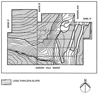 The Braes spreads across the intersection of two creeks and the land slopes down to the creeks. In some places the slope to the creek is quite steep. This complicated surface area is at once an advantage and a disadvantage in the design, remediation and maintenance of the gardens.
While the primary heritage section of the garden is on gently sloping land on top of the rise near Grose Street, the remaining areas of the site provide an interesting contrast by virtue of their changing topography, aspects and relationship to the two creeks. The site offers ample opportunity for reinforcing and extending existing views and vistas.
The Braes lies between an urban environment and a semi-rural one and this enhances the interest in the views of its surrounds.
Geology and Soils
The Braes sits on deep layers of Narrabeen Group sandstone with varying depths of sub-soil including outcrops of clay. The topsoil is good in parts, although the steepness of the slopes makes some areas prone to erosion.
In those areas where the radiata pines were growing, the soil exhibits the typical ill effects of those trees. The soil lacks nutrients, particularly minerals and remediation of the Ph was and continues to be needed wherever they have been.
Both the water quality of the ponds and the soils in each area have been independently tested and remedial action taken to supplement the soil nutrients.
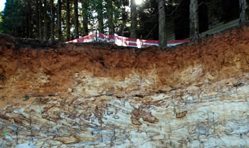
Illustrates minimum top soil depth and variable layers of clay and sandstone fissures.